


Temblor

คำอธิบายของTemblor
A PERSONAL SOLUTION TO A GLOBAL PROBLEM
Half of the world’s population lives near active faults, and so could suffer earthquake damage. Most do not know they are at risk; many of the rest do too little, too late.
Temblor enables everyone in the conterminous United States, and eventually the world, to learn their seismic hazard, to determine what most ensures their safety, and to decide what best reduces their risk.
Temblor works anywhere in the United States, using the best available public data and methods. Our goal is to make earthquake risk ‘real,’ without scaring, soothing, or snowing people. Navigating through Temblor, is quick, fun, and easy. Info buttons explain its calculations, estimates, and data sources.
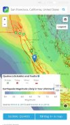
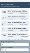
In Temblor’s map you can see the faults and recent quakes around you; use your current location or enter an address. Temblor typically shows magnitude-1.0 or larger quakes in the U.S, and magnitude-4.5 or larger in the rest of the world; the quakes are updated every few minutes. You can click on any quake for more information. Everything is identified in map legends.
The Temblor Seismic Hazard Rank slider lets you know how your location compares to the most and least hazardous sites in the coterminous U.S. By moving the pin around, you can see how your hazard changes, and how it compares to other areas in your commute zone or nearby.
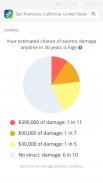
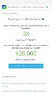
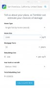
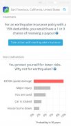
By entering your home’s age and size, Temblor estimates the chances of seismic damage and the cost of repairs in an intuitive, interactive pie chart. Temblor also estimates the cost, and financial and safety benefits of a bolt-and-brace retrofit to your home, so you can assess if this makes sense for you. In addition, Temblor estimates the chances of a payout for a typical earthquake insurance policy for your home at your location.
In an interactive bar chart, Temblor also puts your seismic risk in context. The chart compares your chance of extensive earthquake damage to other perils that most people protect themselves from or insure against, such as a your home burning down or your car being totaled.
In Temblor’s layers menu, you can add liquefaction zones (which can cause a home to sink or tilt when shaken), and landslides (which can cause a home to slide downhill during a quake, or be covered in debris). You can also use a relief map, route map, or satellite image as a base, and zoom in as close as you wish.
Temblor is free and ad-free. Please share Temblor with your friends and family to help our mission to live stronger together.
วิธีการแก้ปัญหาสำหรับบุคคลเป็นปัญหาระดับโลก
ครึ่งหนึ่งของประชากรโลกที่อาศัยอยู่ใกล้ความผิดพลาดของการใช้งานและอื่น ๆ อาจได้รับความเสียหายแผ่นดินไหว ส่วนใหญ่ไม่ได้รู้ว่าพวกเขามีความเสี่ยง; หลายส่วนที่เหลือทำน้อยเกินไปสายเกินไป
temblor ช่วยให้ทุกคนใน conterminous สหรัฐอเมริกาและในที่สุดโลกที่จะเรียนรู้อันตรายจากแผ่นดินไหวของพวกเขาเพื่อตรวจสอบสิ่งที่ดีที่สุดมั่นใจความปลอดภัยของพวกเขาและตัดสินใจเลือกสิ่งที่ดีที่สุดที่ช่วยลดความเสี่ยงของพวกเขา
temblor ทำงานที่ใดก็ได้ในประเทศสหรัฐอเมริกาโดยใช้ข้อมูลที่ดีที่สุดของประชาชนที่มีอยู่และวิธีการ เป้าหมายของเราคือการทำให้ความเสี่ยงแผ่นดินไหว 'จริง' โดยไม่ต้องกลัวผ่อนคลายหรือผู้ที่หิมะตก การนำทางผ่าน temblor เป็นอย่างรวดเร็วสนุกและง่าย ปุ่มข้อมูลอธิบายการคำนวณประมาณการและแหล่งที่มาของข้อมูล
ในแผนที่ temblor ของคุณสามารถเห็นความผิดพลาดและแผ่นดินไหวที่ผ่านมารอบ ๆ ตัวคุณ; ใช้ตำแหน่งปัจจุบันของคุณหรือป้อนที่อยู่ temblor มักจะแสดงให้เห็นถึงความสำคัญ-1.0 หรือไหวขนาดใหญ่ในสหรัฐฯและขนาด-4.5 หรือมีขนาดใหญ่ในส่วนที่เหลือของโลก; ไหวมีการปรับปรุงทุกไม่กี่นาที คุณสามารถคลิกที่สั่นสะเทือนใด ๆ สำหรับข้อมูลเพิ่มเติม ทุกอย่างมีการระบุไว้ในตำนานแผนที่
temblor แผ่นดินไหวอันตรายอันดับเลื่อนช่วยให้คุณทราบว่าสถานที่ของคุณเปรียบเทียบกับเว็บไซต์มากที่สุดและอันตรายน้อยในตัวอ่อนของสหรัฐโดยการย้ายหมุดรอบ ๆ คุณสามารถดูวิธีการเปลี่ยนแปลงความเป็นอันตรายของคุณและวิธีการเปรียบเทียบกับพื้นที่อื่น ๆ ในเขตการเดินทางของคุณหรือ ใกล้เคียง
โดยการป้อนอายุที่บ้านของคุณและขนาด temblor ประมาณการโอกาสของความเสียหายแผ่นดินไหวและค่าใช้จ่ายในการซ่อมแซมในงานง่ายแผนภูมิวงกลมแบบโต้ตอบ temblor ยังประมาณการค่าใช้จ่ายและผลประโยชน์ทางการเงินและความปลอดภัยของ retrofit สายฟ้าและรั้งที่บ้านของคุณเพื่อให้คุณสามารถประเมินว่านี้ทำให้รู้สึกสำหรับคุณ นอกจากนี้ temblor ประมาณการโอกาสของการจ่ายเงินสำหรับนโยบายการประกันแผ่นดินไหวทั่วไปสำหรับบ้านของคุณในสถานที่ของคุณ
ในแผนภูมิแท่งแบบโต้ตอบ temblor ยังทำให้ความเสี่ยงแผ่นดินไหวของคุณในบริบท แผนภูมิเปรียบเทียบโอกาสของการเกิดความเสียหายอย่างกว้างขวางในการเกิดแผ่นดินไหวภัยอื่น ๆ ที่คนส่วนใหญ่ป้องกันตัวเองจากหรือประกันกับเช่นบ้านของคุณการเผาไหม้หรือรถของคุณจะถูกรวมทั้งสิ้น
ในเมนูชั้น temblor ของคุณสามารถเพิ่มโซนเหลว (ซึ่งอาจทำให้เกิดการบ้านที่จะจมหรือเอียงเมื่อเขย่า) และดินถล่ม (ซึ่งอาจทำให้เกิดการบ้านที่จะเลื่อนลงเนินในระหว่างการสั่นสะเทือนหรือจะครอบคลุมในเศษ) นอกจากนี้คุณยังสามารถใช้แผนที่บรรเทาแผนที่เส้นทางหรือภาพจากดาวเทียมเป็นฐานและซูมเข้าใกล้ที่สุดเท่าที่คุณต้องการ
temblor ฟรีและโฆษณาฟรี กรุณาแบ่งปัน temblor กับเพื่อนและครอบครัวของคุณจะช่วยให้ภารกิจของเราจะอยู่ด้วยกันที่แข็งแกร่ง


